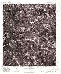
1975 Map of Tallapoosa South
USGS Topo · Published 1977About this map
Tallapoosa River headwaters wind through the wooded hills of Haralson County in this mid-1970s orthophotographic study. This particular imagery, produced in cooperation with the Soil Conservation Service, provides a raw visual record of the land use patterns just south of the main Tallapoosa settlement. The view is dominated by the geometric patterns of clearings and timber tracks, reflecting the area's agricultural and forestry character during this period. The small settlement of Lebanon sits along the western edge, connected by a network of rural roads that contrast sharply with the newer, wide corridor of the interstate highway cutting across the center of the sheet. Unlike a traditional line-drawn map, this aerial perspective captures the exact density of the forest cover and the precise footprint of rural homesteads as they existed in late 1975.
Find a feature on this map
3 named features on this map. Tap any name to fly to it.
Don’t see what you’re looking for? This feature index may not catch every label — zoom into the map to look around manually.
Map Details
Editions of this 1975 Tallapoosa South Map
This is the sole edition of this map. No revisions or reprints were ever made.
Other maps of this area

1889 · Tallapoosa
USGS Topo · 1:125,000

1892 · Tallapoosa
USGS Topo · 1:125,000

1897 · Tallapoosa
USGS Topo · 1:125,000

1953 · Atlanta
USGS Topo · 1:250,000

1957 · Atlanta
USGS Topo · 1:250,000

1958 · Atlanta
USGS Topo · 1:250,000

1958 · Carrollton
USGS Topo · 1:62,500

1958 · Buchanan
USGS Topo · 1:62,500

1965 · Tallapoosa South
USGS Topo · 1:24,000

1966 · Tallapoosa North
USGS Topo · 1:24,000