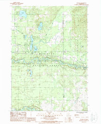
1987 Map of Tallman
USGS Topo · Published 1988About this map
Tallman and Walhalla anchor the northwestern portion of this Mason County landscape, situated within the sprawling boundaries of the Manistee National Forest. The geography is defined by an intricate network of glacial lakes and wetlands, including clusters such as Tallman Lake, Gooseneck Lake, and the adjacent Romeo and Juliet Lakes. A primary transportation corridor follows Us 10, connecting the small settlements and providing access to the woodlands and water bodies that dominate the region.
Find a feature on this map
33 named features on this map. Tap any name to fly to it.
Don’t see what you’re looking for? This feature index may not catch every label — zoom into the map to look around manually.
Map Details
Editions of this 1987 Tallman Map
This is the sole edition of this map. No revisions or reprints were ever made.
Other maps of this area

1931 · Custer NW
USGS Topo · 1:31,680

1931 · Baldwin NW
USGS Topo · 1:31,680

1931 · Custer SW
USGS Topo · 1:31,680

1931 · Custer NE
USGS Topo · 1:31,680

1931 · Freesoil SW
USGS Topo · 1:31,680

1931 · Custer SE
USGS Topo · 1:31,680

1932 · Freesoil SE
USGS Topo · 1:31,680

1933 · Peacock SW
USGS Topo · 1:31,680

1954 · Traverse City
USGS Topo · 1:250,000

1954 · Milwaukee
USGS Topo · 1:250,000