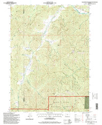
1996 Map of Tallowbox Mountain
USGS Topo · Published 1998About this map
The Josephine and Jackson County line bisects this rugged section of the Siskiyou Mountains, where a long history of resource extraction is evident in the scattered mining claims across the terrain. Gold and quartz mining operations like the Bone of Contention Mine and Layton Mine are positioned along the deep drainages of Ferris Gulch and Bamboo Gulch. The northern edge of the map follows the Applegate River, featuring a Gaging Station and a small Mobile Home Park, while the southern reaches are dominated by the Rogue River National Forest. The landscape is defined by high ridgelines and peaks, including Tallowbox Mountain, which serves as a central landmark overlooking the branching networks of Thompson Creek and Star Gulch. A network of gulches—named for early settlers or distinctive events like Deadman Gulch and Ladybug Gulch—reveals the intricate topography that historically challenged travelers and miners alike.
Find a feature on this map
51 named features on this map. Tap any name to fly to it.
Don’t see what you’re looking for? This feature index may not catch every label — zoom into the map to look around manually.
Map Details
Editions of this 1996 Tallowbox Mountain Map
This is the sole edition of this map. No revisions or reprints were ever made.
Other maps of this area

1908 · Grants Pass
USGS Topo · 1:125,000

1954 · Oregon Caves
USGS Topo · 1:62,500

1954 · Gold Hill
USGS Topo · 1:62,500

1954 · Grants Pass
USGS Topo · 1:62,500

1954 · Ruch
USGS Topo · 1:62,500

1955 · Medford
USGS Topo · 1:250,000

1957 · Medford
USGS Topo · 1:250,000

1958 · Medford
USGS Topo · 1:250,000
1983 · Mt. Isabelle
USGS Topo · 1:24,000
1983 · Squaw Lakes
USGS Topo · 1:24,000