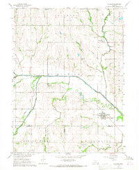
1966 Map of Talmage
USGS Topo · Published 1968About this map
The confluence of the North Fork Little Nemaha River and the South Fork Little Nemaha River anchors this agricultural landscape at the edge of the Otoe and Nemaha county line. The settlement of Talmage serves as the primary hub, where the Missouri Pacific railroad lines parallel the winding river valley. Beyond the village, the map reveals a countryside organized around small community anchors, such as Walnut Hill Sch and rural congregations like St Johns Ch and Delaware Ch.
Find a feature on this map
27 named features on this map. Tap any name to fly to it.
Don’t see what you’re looking for? This feature index may not catch every label — zoom into the map to look around manually.
Map Details
Editions of this 1966 Talmage Map
This is the sole edition of this map. No revisions or reprints were ever made.
Other maps of this area

1903 · Weeping Water
USGS Topo · 1:125,000

1907 · Nebraska City
USGS Topo · 1:62,500

1915 · Howe
USGS Topo · 1:62,500

1929 · Weeping Water
USGS Topo · 1:125,000

1955 · Nebraska City
USGS Topo · 1:250,000

1955 · Lincoln
USGS Topo · 1:250,000

1957 · Nebraska City
USGS Topo · 1:250,000

1957 · Lincoln
USGS Topo · 1:250,000

1958 · Lincoln
USGS Topo · 1:250,000

1958 · Nebraska City
USGS Topo · 1:250,000