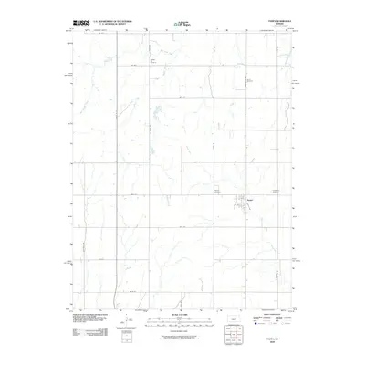
2009 Map of Tampa
USGS Topo · Published 2009About this map
The settlement of Tampa serves as the central hub of this Marion County landscape, situated where Lincoln Ave and 3rd St intersect. The surrounding agricultural terrain is defined by a grid of section roads including Santa Fe Ave and Tampa-Dillon Rd, which cross a drainage system comprising Mud Creek, West Turkey Creek, and Middle Branch. For those tracing local heritage, several significant burial grounds are distributed across the township, such as Saint Mary Cemetery to the east and North Cemetery to the north. Further historical landmarks include College Hill Cemetery and Tampa Cemetery, which provide geographical anchor points for families connected to this prairie community. The mapping reflects the enduring structure of Kansas township divisions, where local watercourses like East Turkey Creek dictated the initial patterns of land use and road placement.
Find a feature on this map
29 named features on this map. Tap any name to fly to it.
Don’t see what you’re looking for? This feature index may not catch every label — zoom into the map to look around manually.
Map Details
Editions of this 2009 Tampa Map
This is the sole edition of this map. No revisions or reprints were ever made.
Other maps of this area

1889 · Newton
USGS Topo · 1:125,000

1889 · Abilene
USGS Topo · 1:125,000

1894 · Newton
USGS Topo · 1:125,000

1894 · Abilene
USGS Topo · 1:125,000

1955 · Hutchinson
USGS Topo · 1:250,000

1959 · Hutchinson
USGS Topo · 1:250,000

1964 · Elmo
USGS Topo · 1:24,000

1964 · Carlton
USGS Topo · 1:24,000

1964 · Ramona
USGS Topo · 1:24,000
1964 · Hope
USGS Topo · 1:24,000