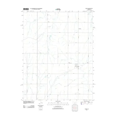
2012 Map of Tampa
USGS Topo · Published 2012About this map
Tampa serves as the central hub of this Marion County agricultural landscape, situated at the intersection of Limestone and 330th roads. The town's grid is small but distinct, with residential streets like 3rd St and 5th St providing structure to the community. The surrounding terrain is defined by the drainage patterns of Mud Cr and the various branches of Turkey Creek, including W Turkey Cr and Middle Br. Genealogists will find significant value in the distribution of local burial grounds throughout the countryside, such as Coll Hill Cem to the northwest and Saint Mary Cem just east of the main settlement. These sites, along with Saint John's Lutheran Cem and Hackler Community Cem, suggest a history of tight-knit rural congregations and family farmsteads that have long worked this section of the Kansas plains.
Find a feature on this map
33 named features on this map. Tap any name to fly to it.
Don’t see what you’re looking for? This feature index may not catch every label — zoom into the map to look around manually.
Map Details
Editions of this 2012 Tampa Map
This is the sole edition of this map. No revisions or reprints were ever made.
Other maps of this area

1889 · Newton
USGS Topo · 1:125,000

1889 · Abilene
USGS Topo · 1:125,000

1894 · Newton
USGS Topo · 1:125,000

1894 · Abilene
USGS Topo · 1:125,000

1955 · Hutchinson
USGS Topo · 1:250,000

1959 · Hutchinson
USGS Topo · 1:250,000

1964 · Elmo
USGS Topo · 1:24,000

1964 · Carlton
USGS Topo · 1:24,000

1964 · Ramona
USGS Topo · 1:24,000
1964 · Hope
USGS Topo · 1:24,000