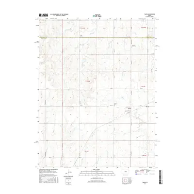
2015 Map of Tampa
USGS Topo · Published 2015About this map
The settlement of Tampa serves as the focal point for this rural Kansas landscape, situated near the boundary where Dickinson Co and Marion Co meet. The township is characterized by a grid of agricultural section lines and the winding paths of local waterways like Mud Cr and the Middle Br. Local genealogy is well-documented through several established burial grounds, including Saint Mary Cem just east of the main town site and the Hackler Community Cem to its west.
Find a feature on this map
36 named features on this map. Tap any name to fly to it.
Don’t see what you’re looking for? This feature index may not catch every label — zoom into the map to look around manually.
Map Details
Editions of this 2015 Tampa Map
This is the sole edition of this map. No revisions or reprints were ever made.
Other maps of this area

1889 · Newton
USGS Topo · 1:125,000

1889 · Abilene
USGS Topo · 1:125,000

1894 · Newton
USGS Topo · 1:125,000

1894 · Abilene
USGS Topo · 1:125,000

1955 · Hutchinson
USGS Topo · 1:250,000

1959 · Hutchinson
USGS Topo · 1:250,000

1964 · Elmo
USGS Topo · 1:24,000

1964 · Carlton
USGS Topo · 1:24,000

1964 · Ramona
USGS Topo · 1:24,000
1964 · Hope
USGS Topo · 1:24,000