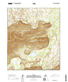
2017 Map of Tanana A-1 SW
USGS Topo · Published 2017About this map
Manley Hot Springs serves as the focal point of this interior Alaskan landscape, situated near the confluence of Hot Springs Slough and the winding course of Baker Cr. The terrain is defined by significant elevations such as Bean Ridge and the prominent Overland Bluff, which overlooks the valley floor. Water dominates the lowland geography, with Baker Lake and numerous tributary systems like Hutlinana Cr, Rhode Island Cr, and Eureka Cr draining the surrounding uplands. The Elliott Highway provides the primary overland corridor, cutting through the center of the sheet and connecting these remote waterways. This 2017 survey illustrates a classic subarctic drainage pattern where local relief and thermal features have historically dictated the placement of human habitation and transportation routes.
Find a feature on this map
18 named features on this map. Tap any name to fly to it.
Don’t see what you’re looking for? This feature index may not catch every label — zoom into the map to look around manually.
Map Details
Editions of this 2017 Tanana A-1 SW Map
This is the sole edition of this map. No revisions or reprints were ever made.
Other maps of this area

1948 · Kantishna River
USGS Topo · 1:250,000

1951 · Kantishna River
USGS Topo · 1:250,000

1951 · Tanana
USGS Topo · 1:250,000

1952 · Tanana A-1
USGS Topo · 1:63,360

1952 · Tanana A-2
USGS Topo · 1:63,360

1952 · Kantishna River
USGS Topo · 1:250,000

1952 · Kantishna River D-2
USGS Topo · 1:63,360

1953 · Tanana A-2
USGS Topo · 1:63,360
1953 · Kantishna River D-1
USGS Topo · 1:63,360
1954 · Kantishna River D-1
USGS Topo · 1:63,360