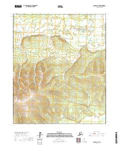
2017 Map of Tanana A-2 SE
USGS Topo · Published 2017About this map
Manley Hot Springs anchors the southern portion of this landscape, situated near the confluence of Kushner Cr and the winding Hot Springs Slough. The terrain is defined by the significant rise of Manley Hot Springs Dome to the west, with the Elliott Highway providing the primary corridor of transit through the valley. This interior region is characterized by a dense network of watercourses, including Baker Cr and Gold Basin Cr, which drain the uplands that separate the various townships. Evidence of local access and historic travel routes is found in the path of the Tofty Road, which snakes through the center of the sheet toward the northern drainage basins. The presence of Hot Spring and numerous family-named creeks such as McCloud Ranch Cr and Sunde Cr suggests a landscape shaped by early settlement and localized prospecting.
Find a feature on this map
24 named features on this map. Tap any name to fly to it.
Don’t see what you’re looking for? This feature index may not catch every label — zoom into the map to look around manually.
Map Details
Editions of this 2017 Tanana A-2 SE Map
This is the sole edition of this map. No revisions or reprints were ever made.
Other maps of this area

1948 · Kantishna River
USGS Topo · 1:250,000

1951 · Kantishna River
USGS Topo · 1:250,000

1951 · Tanana
USGS Topo · 1:250,000

1952 · Tanana A-1
USGS Topo · 1:63,360

1952 · Tanana A-2
USGS Topo · 1:63,360

1952 · Kantishna River
USGS Topo · 1:250,000

1952 · Kantishna River D-2
USGS Topo · 1:63,360

1953 · Tanana A-2
USGS Topo · 1:63,360
1953 · Kantishna River D-1
USGS Topo · 1:63,360
1954 · Kantishna River D-1
USGS Topo · 1:63,360