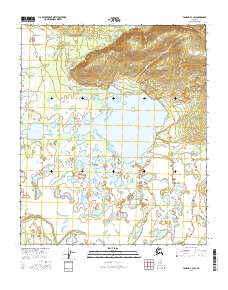
2016 Map of Tanana A-3 SW
USGS Topo · Published 2016About this map
Fish Lake dominates the central portion of this landscape, surrounded by a complex system of ponds and marshes that characterize the interior of the Tanana region. The drainage patterns are defined by a network of wandering waterways including Fish Cr, American Cr, and Eldorado Creek which snake through the flat lowlands. This environment is punctuated by larger water bodies such as Spring Camp Lake and Long Lake, suggesting a terrain shaped by heavy seasonal saturation and alluvial deposits. Higher ground appears to the north, where the topography rises toward hills drained by Boulder Cr and Blueberry Cr. The lack of road infrastructure and the prevalence of sloughs like Hay Slough underscore the reliance on natural water corridors for navigation through this wilderness in the early twenty-first century.
Find a feature on this map
22 named features on this map. Tap any name to fly to it.
Don’t see what you’re looking for? This feature index may not catch every label — zoom into the map to look around manually.
Map Details
Editions of this 2016 Tanana A-3 SW Map
This is the sole edition of this map. No revisions or reprints were ever made.
Other maps of this area

1948 · Kantishna River
USGS Topo · 1:250,000

1951 · Kantishna River
USGS Topo · 1:250,000

1951 · Tanana
USGS Topo · 1:250,000

1952 · Tanana A-3
USGS Topo · 1:63,360

1952 · Tanana A-4
USGS Topo · 1:63,360

1952 · Kantishna River
USGS Topo · 1:250,000

1952 · Kantishna River D-3
USGS Topo · 1:63,360

1953 · Tanana A-3
USGS Topo · 1:63,360
1953 · Kantishna River D-4
USGS Topo · 1:63,360
1954 · Kantishna River D-3
USGS Topo · 1:63,360