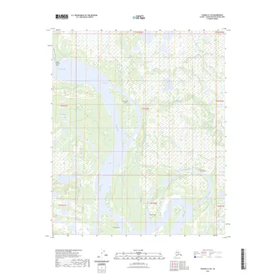
2023 Map of Tanana A-4 SE
USGS Topo · Published 2023About this map
The Tanana River dominates this interior Alaskan landscape, carving a complex network of braided channels and seasonal waterways. Its shifting course is evidenced by landforms like Fish Creek Island, Murray Island, and the sharp turn at Harper Bend. This aqueous environment is defined by an intricate system of sloughs, including Aeolian Crossing Slough and Shortcut Slough, which serve as vital conduits through the marshy lowlands. Away from the main river channel, the map records the Fort Yukon Community Cem near the eastern bank, a significant site for local history and genealogy. The terrain is further segmented by smaller drainages such as Fish Creek, Hay Slough, and Patterson Creek, illustrating the dynamic nature of the subarctic riverine ecosystem before it reaches the Aeolian Crossing Point.
Find a feature on this map
20 named features on this map. Tap any name to fly to it.
Don’t see what you’re looking for? This feature index may not catch every label — zoom into the map to look around manually.
Map Details
Editions of this 2023 Tanana A-4 SE Map
This is the sole edition of this map. No revisions or reprints were ever made.
Other maps of this area

1948 · Kantishna River
USGS Topo · 1:250,000

1951 · Kantishna River
USGS Topo · 1:250,000

1951 · Tanana
USGS Topo · 1:250,000

1952 · Tanana A-3
USGS Topo · 1:63,360

1952 · Tanana A-4
USGS Topo · 1:63,360

1952 · Kantishna River
USGS Topo · 1:250,000

1952 · Kantishna River D-3
USGS Topo · 1:63,360

1953 · Tanana A-3
USGS Topo · 1:63,360
1953 · Kantishna River D-4
USGS Topo · 1:63,360
1954 · Kantishna River D-3
USGS Topo · 1:63,360