
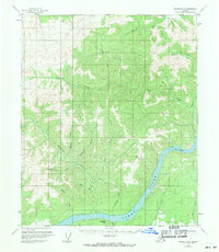
1956 Map of Tanana B-3
USGS Topo · Published 1960About this map
The Yukon River cuts a wide path through this interior Alaska landscape, serving as the primary geographical anchor for a region defined by its waterway and mining history. Several small structures, simply labeled Cabin, are scattered along the riverbank and deeper into the tributary valleys, suggesting seasonal use by prospectors or trappers. In the mid-1950s, the extractive potential of the land is highlighted by a Placer Mine situated along Rosa Creek, while the presence of Bonanza Creek and Homestake Creek points to the area's gold-seeking heritage.
Find a feature on this map
18 named features on this map. Tap any name to fly to it.
Don’t see what you’re looking for? This feature index may not catch every label — zoom into the map to look around manually.
Map Details
Editions of this 1956 Tanana B-3 Map
2 editions found
Other maps of this area

1951 · Tanana
USGS Topo · 1:250,000

1952 · Tanana A-3
USGS Topo · 1:63,360

1952 · Tanana A-2
USGS Topo · 1:63,360

1952 · Tanana A-4
USGS Topo · 1:63,360

1953 · Tanana A-2
USGS Topo · 1:63,360

1953 · Tanana A-3
USGS Topo · 1:63,360

1956 · Tanana B-2
USGS Topo · 1:63,360

1956 · Tanana C-3
USGS Topo · 1:63,360

1956 · Tanana C-2
USGS Topo · 1:63,360

1956 · Tanana C-4
USGS Topo · 1:63,360