
1956 Map of Tanana C-4
USGS Topo · Published 1960About this map
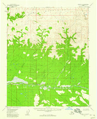
Ray Mountains dominate the northern terrain of this interior Alaskan landscape, their peaks giving way to a network of drainage systems that flow south toward the Tozitna River. This mid-century survey, based on 1953 aerial photography, reveals a wilderness largely devoid of human infrastructure, with no roads or trails recorded at the time of publication. The intricate contour work illustrates the steep descent from the northern heights into the broad, swampy basin of the Tozitna River, which meanders through the southern portion of the quadrangle. Significant watercourses like McQuisten Creek and Banddana Creek carve through the high ground, while Crooked Creek winds through the central elevations. The map serves as a primary record of the region's natural hydrography and topography before significant modern development or climate-driven changes altered the interior subarctic drainage patterns.
Find a feature on this map
5 named features on this map. Tap any name to fly to it.
Don’t see what you’re looking for? This feature index may not catch every label — zoom into the map to look around manually.
Map Details
Editions of this 1956 Tanana C-4 Map
2 editions found
Other maps of this area

1951 · Tanana
USGS Topo · 1:250,000

1956 · Tanana B-5
USGS Topo · 1:63,360

1956 · Tanana D-4
USGS Topo · 1:63,360

1956 · Tanana D-3
USGS Topo · 1:63,360

1956 · Tanana C-3
USGS Topo · 1:63,360

1956 · Tanana B-3
USGS Topo · 1:63,360

1956 · Tanana C-5
USGS Topo · 1:63,360
1956 · Tanana D-5
USGS Topo · 1:63,360

1956 · Tanana B-4
USGS Topo · 1:63,360

1956 · Tanana
USGS Topo · 1:250,000