
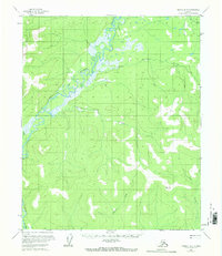
1956 Map of Tanana B-5
USGS Topo · Published 1960About this map
The Tozitna River meanders sharply across this mid-century Alaskan interior landscape, creating a complex network of oxbows and wetlands in the northwestern quadrant. Mapped during the mid-1950s using aerial photography, the terrain is defined by a series of significant drainage systems, including the west-flowing Reindeer Creek and the southern reaches of Tenmile Creek. The absence of established roads or structures on this sheet underscores the isolation of the Yukon-Koyukuk region at the time of the survey. Instead, the geography is dictated by the natural corridors of Hellbent Creek and Bear Creek, which cut through the varying elevations of the Tanana quadrangle. This document provides a record of the unsurveyed and unmarked land lines as predetermined by the Bureau of Land Management, offering a foundational view of the area's hydrology and topography before further development or modern environmental changes.
Find a feature on this map
6 named features on this map. Tap any name to fly to it.
Don’t see what you’re looking for? This feature index may not catch every label — zoom into the map to look around manually.
Map Details
Editions of this 1956 Tanana B-5 Map
2 editions found
Other maps of this area

1951 · Tanana
USGS Topo · 1:250,000

1952 · Tanana A-4
USGS Topo · 1:63,360

1952 · Tanana A-6
USGS Topo · 1:63,360

1952 · Tanana A-5
USGS Topo · 1:63,360

1953 · Tanana A-5
USGS Topo · 1:63,360

1956 · Tanana B-6
USGS Topo · 1:63,360

1956 · Tanana C-6
USGS Topo · 1:63,360

1956 · Tanana C-5
USGS Topo · 1:63,360

1956 · Tanana C-4
USGS Topo · 1:63,360

1956 · Tanana B-4
USGS Topo · 1:63,360