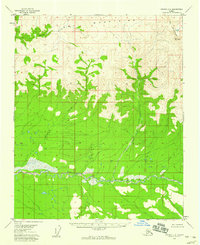
1956 Map of Tanana C-4
USGS Topo · Published 1960About this map
The Tozitna River meanders across this interior Alaskan landscape, defining the southern drainage of the formidable Ray Mountains. Surveyed in the mid-1950s using photogrammetric methods from aerial photography, the map reveals a remote wilderness devoid of established roads or trails during this era. High-elevation drainages such as Ray Creek and Banddana Creek carve through the northern peaks, while the southern slopes are marked by the winding courses of McQuisten Creek and Crooked Creek. The terrain is characterized by a complex network of unnamed ridges and wet lowlands, illustrating the raw geography of the Yukon-Koyukuk region before significant modern encroachment. This document captures the topographical character of the land exactly as it stood when the first systematic aerial surveys were being finalized for the Interior.
Find a feature on this map
6 named features on this map. Tap any name to fly to it.
Don’t see what you’re looking for? This feature index may not catch every label — zoom into the map to look around manually.
Map Details
Editions of this 1956 Tanana C-4 Map
2 editions found
Other maps of this area

1951 · Tanana
USGS Topo · 1:250,000

1956 · Tanana B-5
USGS Topo · 1:63,360

1956 · Tanana D-4
USGS Topo · 1:63,360

1956 · Tanana D-3
USGS Topo · 1:63,360

1956 · Tanana C-3
USGS Topo · 1:63,360

1956 · Tanana B-3
USGS Topo · 1:63,360

1956 · Tanana C-5
USGS Topo · 1:63,360
1956 · Tanana D-5
USGS Topo · 1:63,360

1956 · Tanana C-4
USGS Topo · 1:63,360

1956 · Tanana B-4
USGS Topo · 1:63,360