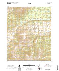
2017 Map of Tanana D-2 NW
USGS Topo · Published 2017About this map
Ray River Hot Spring marks a rare geothermal point of interest within this interior landscape, located along the winding course of the Ray River. This 2017 survey of the Yukon-Koyukuk Census Area reveals a terrain defined primarily by its hydrology and high-latitude topography. The map illustrates the meandering path of the river as it flows through the township boundaries of t13n r16w and t14n r16w, showing the natural drainage patterns of the region. Without roads or permanent settlements recorded, the map emphasizes the remote character of the Alaskan interior, providing an essential resource for understanding the physical geography and natural features of the Tanana D-2 NW quadrangle.
Find a feature on this map
8 named features on this map. Tap any name to fly to it.
Don’t see what you’re looking for? This feature index may not catch every label — zoom into the map to look around manually.
Map Details
Editions of this 2017 Tanana D-2 NW Map
This is the sole edition of this map. No revisions or reprints were ever made.
Other maps of this area

1951 · Bettles
USGS Topo · 1:250,000

1951 · Tanana
USGS Topo · 1:250,000

1956 · Bettles
USGS Topo · 1:250,000

1956 · Tanana D-2
USGS Topo · 1:63,360

1956 · Tanana D-3
USGS Topo · 1:63,360

1956 · Tanana
USGS Topo · 1:250,000

1960 · Tanana
USGS Topo · 1:250,000
1970 · Bettles A-3
USGS Topo · 1:63,360
1970 · Bettles A-2
USGS Topo · 1:63,360
2016 · Bettles A-3 SE
USGS Topo · 1:25,000