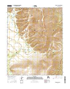
2016 Map of Tanana D-3 NE
USGS Topo · Published 2016About this map
Kanuti Kilolitna River meanders across the northwest and southwest portions of this interior Alaskan landscape, defining the drainage patterns of the central Tanana region. The topography is dominated by significant elevation gains, with numerous unnamed peaks rising between the river valleys. Seasonal watercourses including Torment Cr in the northwest and Allard Cr in the south drain the higher ground. The Ray River makes a brief appearance in the far southeastern corner. This area is notable for its lack of human infrastructure, focusing entirely on the complex hydrography and natural relief of the Yukon-Koyukuk region. Researchers can trace the subtle township and range divisions such as t13n r17w and t12n r17w that impose a grid over this wilderness terrain.
Find a feature on this map
10 named features on this map. Tap any name to fly to it.
Don’t see what you’re looking for? This feature index may not catch every label — zoom into the map to look around manually.
Map Details
Editions of this 2016 Tanana D-3 NE Map
This is the sole edition of this map. No revisions or reprints were ever made.
Other maps of this area

1951 · Bettles
USGS Topo · 1:250,000

1951 · Tanana
USGS Topo · 1:250,000

1956 · Bettles
USGS Topo · 1:250,000

1956 · Tanana D-2
USGS Topo · 1:63,360

1956 · Tanana D-3
USGS Topo · 1:63,360

1956 · Tanana
USGS Topo · 1:250,000

1960 · Tanana
USGS Topo · 1:250,000
1970 · Bettles A-3
USGS Topo · 1:63,360
1970 · Bettles A-2
USGS Topo · 1:63,360
2016 · Bettles A-3 SE
USGS Topo · 1:25,000