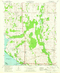
1963 Map of Tanner
USGS Topo · Published 1966About this map
Wheeler Lake and its intricate shoreline dominate the southern edge of this Limestone County landscape, reflecting the massive water management projects of the mid-20th century. The Wheeler National Wildlife Refuge and the Wheeler Waterfowl Management Area define the transition from the Tennessee River to the fertile agricultural plains. Settlement patterns here are deeply tied to the railroads, with Harris Station and Tanner situated along the Louisville and Nashville line, while the Southern railway serves the community of Belle Mina. The presence of the Auburn Experimental Station and the Tennessee Valley State Vocational-Technical School underscores the era's focus on technical and agricultural advancement. For local historians, family-named landmarks like Murphree Place and Anderson Plantation sit alongside numerous small cemeteries, including Gamble Cem and Solomons Temple Cem, documenting the area's rural genealogy.
Find a feature on this map
60 named features on this map. Tap any name to fly to it.
Don’t see what you’re looking for? This feature index may not catch every label — zoom into the map to look around manually.
Map Details
Editions of this 1963 Tanner Map
3 editions found
Other maps of this area

1888 · Huntsville
USGS Topo · 1:125,000

1892 · Huntsville
USGS Topo · 1:125,000

1935 · Athens
USGS Topo · 1:24,000

1936 · Capshaw
USGS Topo · 1:24,000

1936 · Decatur
USGS Topo · 1:24,000

1936 · Stewart Cross Roads
USGS Topo · 1:24,000

1936 · Ripley
USGS Topo · 1:24,000

1936 · Trinity
USGS Topo · 1:24,000

1936 · Mason Ridge
USGS Topo · 1:24,000

1936 · Tanner
USGS Topo · 1:24,000