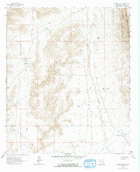
1963 Map of Tanner Ranch
USGS Topo · Published 1965About this map
Jernigan Homestead and several family-named ranching outposts define this high-desert landscape in the early 1960s. The terrain is characterized by the dramatic escarpment of The Rim, which marks a sharp transition into the Lincoln National Forest along the eastern edge. Water management is central to life here, as evidenced by a network of engineered catchments including Dee Tank, Hook Tank, and Johnson Tanks. These features, along with an extensive Pipeline, illustrate the infrastructure required to sustain cattle at locations like Tanner Ranch and Cauhaupe Ranch. Drainage patterns are carved by the seasonal flows of Jernigan Wash and Piñon Creek, which dictate the placement of roads and homesteads across this corner of Otero County.
Find a feature on this map
15 named features on this map. Tap any name to fly to it.
Don’t see what you’re looking for? This feature index may not catch every label — zoom into the map to look around manually.
Map Details
Editions of this 1963 Tanner Ranch Map
2 editions found
Other maps of this area

1954 · Carlsbad
USGS Topo · 1:250,000

1958 · Carlsbad
USGS Topo · 1:250,000

1963 · Cornucopia Canyon
USGS Topo · 1:24,000

1963 · Hackberry Hill
USGS Topo · 1:24,000
1963 · Cornucopia Ranch SE
USGS Topo · 1:24,000

1963 · Tanner Ranch
USGS Topo · 1:24,000

1963 · Gowdy Ranch
USGS Topo · 1:24,000

1963 · Panama Ranch
USGS Topo · 1:24,000

1965 · Bullis Spring Ranch
USGS Topo · 1:24,000

1965 · Pinon Ranch
USGS Topo · 1:24,000