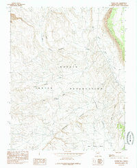
1985 Map of Tanner Well
USGS Topo · Published 1985About this map
The Navajo Indian Reservation landscape is defined here by striking geological formations and critical water sources in Coconino County. The towering Echo Cliffs dominate the eastern edge of the survey, while the center is marked by the deep drainage of Tanner Wash and the complex terrain of Hanaa Ridge. Human activity and ranching heritage are anchored by scattered watering points like Tanner Well, Limestone Tank, and the naturally occurring Sheep Spring. To the south, the terrain falls away at the Limestone Break, leading toward the Gray Grass Bench. This 1985 provisional edition, based on earlier field checks, traces a network of unnamed trails and unimproved roads connecting these isolated landmarks, including Tsin Yaa To and the Pine Reservoir, illustrating the geographic isolation and specialized water management in this arid territory.
Find a feature on this map
19 named features on this map. Tap any name to fly to it.
Don’t see what you’re looking for? This feature index may not catch every label — zoom into the map to look around manually.
Map Details
Editions of this 1985 Tanner Well Map
This is the sole edition of this map. No revisions or reprints were ever made.
Other maps of this area

1886 · Echo Cliffs
USGS Topo · 1:250,000

1891 · Echo Cliffs
USGS Topo · 1:250,000

1954 · Emmett Wash NE
USGS Topo · 1:24,000

1954 · Shinumo Altar NE
USGS Topo · 1:24,000

1954 · Nankoweap
USGS Topo · 1:62,500

1954 · Tanner Wash
USGS Topo · 1:62,500

1954 · Emmett Wash
USGS Topo · 1:62,500

1954 · Shinumo Altar
USGS Topo · 1:62,500

1955 · Tanner Wash NE
USGS Topo · 1:24,000

1956 · Marble Canyon
USGS Topo · 1:250,000