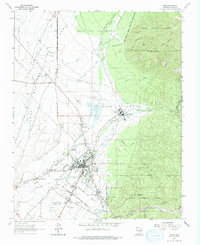
1964 Map of Taos
USGS Topo · Published 1974About this map
Taos Pueblo stands at the foot of the mountains, a historic adobe community bordered by the Rio Lucero and Rio Pueblo de Taos. This mid-century survey illustrates the intricate boundary lines of ancient land grants, including the Antoine Leroux Grant and the Taos Pueblo Grant, which intersect the high desert landscape. The town of Taos serves as the central hub, surrounded by smaller settlements like El Prado, Ranchito, and Cañon.
Find a feature on this map
68 named features on this map. Tap any name to fly to it.
Don’t see what you’re looking for? This feature index may not catch every label — zoom into the map to look around manually.
Map Details
Editions of this 1964 Taos Map
2 editions found
Other maps of this area

1954 · Raton
USGS Topo · 1:250,000

1958 · Raton
USGS Topo · 1:250,000

1963 · Wheeler Peak
USGS Topo · 1:24,000

1963 · Arroyo Seco
USGS Topo · 1:24,000

1963 · Arroyo Hondo
USGS Topo · 1:24,000

1964 · Los Cordovas
USGS Topo · 1:24,000

1964 · Taos
USGS Topo · 1:24,000

1964 · Ranchos De Taos
USGS Topo · 1:24,000

1964 · Taos SW
USGS Topo · 1:24,000

1965 · Pueblo Peak
USGS Topo · 1:24,000