
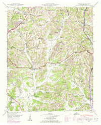
1936 Map of Tarpley
USGS Topo · Published 1936About this map
Tarpley and the rural hills of southern Tennessee are captured here through a meticulous 1936 field examination. This landscape is defined by its social network of small country churches and schools, such as Sharon Ch, Rehoboth Ch, and Aymett Town Sch. The terrain is deeply dissected by a dense drainage network including Hurricane Creek, Birdsong Creek, and Indian Creek, with settlements like Sumac and Friendship positioned along early ridges and creek bottoms. The presence of Tennessee Valley Authority boundaries reflects the federal infrastructure efforts of the Great Depression era. Notable family names are preserved through landmarks like Maxwell Hill, Ingram Hill, and several private burial grounds like Worley Cem and Harris Cem. The map serves as a detailed record of the pre-war agricultural landscape, showing the distribution of homesteads and the early path of State Highway No 64.
Find a feature on this map
80 named features on this map. Tap any name to fly to it.
Don’t see what you’re looking for? This feature index may not catch every label — zoom into the map to look around manually.
Map Details
Editions of this 1936 Tarpley Map
This is the sole edition of this map. No revisions or reprints were ever made.
Other maps of this area

1936 · Milky Way
USGS Topo · 1:24,000

1936 · Aspen Hill
USGS Topo · 1:24,000

1936 · Cornersville
USGS Topo · 1:24,000

1936 · Brick Church
USGS Topo · 1:24,000

1936 · Pulaski
USGS Topo · 1:24,000

1936 · Elkton
USGS Topo · 1:24,000

1936 · Frankewing
USGS Topo · 1:24,000

1936 · Dellrose
USGS Topo · 1:24,000

1946 · Brick Church
USGS Topo · 1:24,000
1948 · Tarpley
USGS Topo · 1:24,000