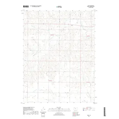
2018 Map of Tasco
USGS Topo · Published 2018About this map
Tasco sits at the northern end of this Sheridan County landscape, where the high plains are carved by a series of south-flowing drainage systems. The S Fork Solomon River winds across the northern sections, while the southern portion of the quadrangle is defined by the headwaters of the N Fork Saline River. This hydrologic divide separates two major river systems in western Kansas, showing a terrain shaped by the slow erosion of several creeks including Sand Cr, Cortez Cr, and S Martin Cr. A rigid grid of section-line roads like Co Rd 503 and Rd 10 S overlays the natural topography, illustrating the late-stage development of the rural agricultural landscape. The map provides a detailed record of the intersections and local routes that connect this remote corner of the state.
Find a feature on this map
32 named features on this map. Tap any name to fly to it.
Don’t see what you’re looking for? This feature index may not catch every label — zoom into the map to look around manually.
Map Details
Editions of this 2018 Tasco Map
This is the sole edition of this map. No revisions or reprints were ever made.
Other maps of this area

1954 · Goodland
USGS Topo · 1:250,000

1956 · Goodland
USGS Topo · 1:250,000

1957 · Goodland
USGS Topo · 1:250,000
1979 · Lucerne
USGS Topo · 1:24,000
1979 · Midway Draw West
USGS Topo · 1:24,000
1979 · Midway Draw East
USGS Topo · 1:24,000
1979 · Hoxie
USGS Topo · 1:24,000
1979 · Hoxie NE
USGS Topo · 1:24,000
1979 · Tasco
USGS Topo · 1:24,000
1979 · Studley
USGS Topo · 1:24,000