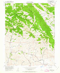
1953 Map of Tassajara
USGS Topo · Published 1963About this map
Morgan Territory and the Black Hills dominate the topography of this 1950s survey, a landscape defined by deep drainages and cattle-ranching infrastructure. The small settlement of Tassajara sits at the junction of Tassajara Road and Highland Road, serving as a central point for the surrounding rural community. Evidence of shifting social patterns is visible in the presence of Tassajara Sch and Highland Sch, both marked as abandoned by 1953, reflecting the consolidation of rural school districts during this era.
Find a feature on this map
33 named features on this map. Tap any name to fly to it.
Don’t see what you’re looking for? This feature index may not catch every label — zoom into the map to look around manually.
Map Details
Editions of this 1953 Tassajara Map
4 editions found
Other maps of this area

1896 · Mt. Diablo
USGS Topo · 1:62,500

1898 · Mt. Diablo
USGS Topo · 1:62,500

1906 · Pleasanton
USGS Topo · 1:62,500

1907 · Tesla
USGS Topo · 1:62,500

1911 · Byron Hot Springs
USGS Topo · 1:31,680

1914 · Brentwood
USGS Topo · 1:31,680

1916 · Lone Tree Valley
USGS Topo · 1:31,680

1916 · Byron Hot Springs
USGS Topo · 1:31,680

1916 · Byron
USGS Topo · 1:62,500

1940 · Byron
USGS Topo · 1:62,500