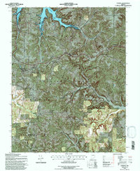
1993 Map of Taswell
USGS Topo · Published 1996About this map
Taswell and Eckerty anchor this portion of the Crawford County landscape, where the wooded expanses of the Hoosier National Forest meet the controlled waters of Patoka Lake. The mapping reveals a rural infrastructure defined by small crossroads settlements and community landmarks such as Bethany Ch, Bethel Ch, and the Pleasant Ridge Ch Cem. These sites, along with the Gilmore Cem and Mt Eden Cem, offer essential touchpoints for genealogical research in southern Indiana.
Find a feature on this map
30 named features on this map. Tap any name to fly to it.
Don’t see what you’re looking for? This feature index may not catch every label — zoom into the map to look around manually.
Map Details
Editions of this 1993 Taswell Map
This is the sole edition of this map. No revisions or reprints were ever made.
Other maps of this area

1950 · Beechwood
USGS Topo · 1:24,000

1950 · Valeene
USGS Topo · 1:24,000

1950 · English
USGS Topo · 1:24,000

1950 · Alton
USGS Topo · 1:62,500

1956 · Greenbrier
USGS Topo · 1:24,000

1956 · Taswell
USGS Topo · 1:24,000

1956 · Vincennes
USGS Topo · 1:250,000

1957 · Vincennes
USGS Topo · 1:250,000

1957 · Cuzco
USGS Topo · 1:24,000

1957 · Birdseye
USGS Topo · 1:24,000