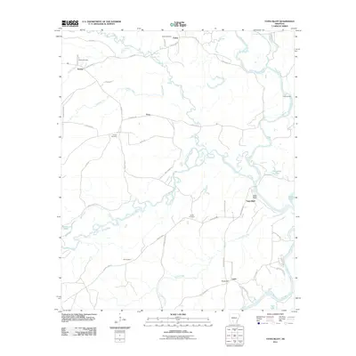
2011 Map of Tates Bluff
USGS Topo · Published 2011About this map
Tates Bluff overlooks the confluence where the Little Missouri River meets the Ouachita River, a point of historical significance for river navigation and local settlement. This 2011 survey illustrates the rural landscape of Ouachita County, defined by its intricate drainage system including Terre Noire Creek, French Creek, and Cypress Creek. Several small, localized settlements like Vaden, Kansas, and Lunet are connected by a network of county roads, with many family and community names preserved through sites such as the Vaden Cemetery, McGill Cemetery, and Hill Cemetery. The presence of Rucks Landing on the Ouachita River and Barton Lake near the western edge reflects the area's continued reliance on its waterways for both geography and identity. The map provides a detailed view of the rural topography before more modern development might further alter these historic connections between land and water.
Find a feature on this map
56 named features on this map. Tap any name to fly to it.
Don’t see what you’re looking for? This feature index may not catch every label — zoom into the map to look around manually.
Map Details
Editions of this 2011 Tates Bluff Map
This is the sole edition of this map. No revisions or reprints were ever made.
Other maps of this area

1901 · Gurdon
USGS Topo · 1:125,000

1903 · Camden
USGS Topo · 1:125,000

1953 · El Dorado
USGS Topo · 1:250,000

1957 · El Dorado
USGS Topo · 1:250,000

1958 · El Dorado
USGS Topo · 1:250,000

1960 · El Dorado
USGS Topo · 1:250,000

1970 · Reader
USGS Topo · 1:24,000
1970 · Curtis
USGS Topo · 1:24,000

1971 · Tates Bluff
USGS Topo · 1:24,000
1971 · Sparkman
USGS Topo · 1:24,000