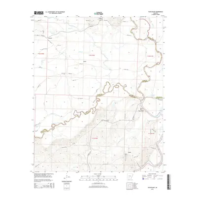
2014 Map of Tates Bluff
USGS Topo · Published 2014About this map
Tates Bluff overlooks the confluence of the Little Missouri River and the Ouachita River, marking a point where the borders of Clark, Dallas, and Ouachita counties meet. This 2014 survey captures a landscape defined by its winding waterways and deep-rooted rural settlements such as Kansas, Vaden, and Trace. The terrain is characterized by low-lying bottomlands near Barton Lake and Bacon Lake, transitioning into the higher ground of Rocky Hill. For genealogists and local historians, the sheet is particularly valuable for its documentation of family-named cemeteries and landmarks. Small burial grounds like Easley Cem, Kansas Cem, and McGill Cem are preserved here, tucked away near timber tracts and seasonal creeks like Terre Noire Creek and Cypress Cr. The intricate network of local roads, such as McGill Ford Rd and Vaden Rd, illustrates the persistent connectivity between these remote Arkansas communities.
Find a feature on this map
67 named features on this map. Tap any name to fly to it.
Don’t see what you’re looking for? This feature index may not catch every label — zoom into the map to look around manually.
Map Details
Editions of this 2014 Tates Bluff Map
This is the sole edition of this map. No revisions or reprints were ever made.
Other maps of this area

1901 · Gurdon
USGS Topo · 1:125,000

1903 · Camden
USGS Topo · 1:125,000

1953 · El Dorado
USGS Topo · 1:250,000

1957 · El Dorado
USGS Topo · 1:250,000

1958 · El Dorado
USGS Topo · 1:250,000

1960 · El Dorado
USGS Topo · 1:250,000

1970 · Reader
USGS Topo · 1:24,000
1970 · Curtis
USGS Topo · 1:24,000

1971 · Tates Bluff
USGS Topo · 1:24,000
1971 · Sparkman
USGS Topo · 1:24,000