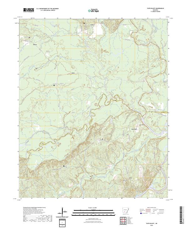
2024 Map of Tates Bluff
USGS Topo · Published 2024About this map
Tates Bluff overlooks the confluence where the Little Missouri River meets the Ouachita River, marking a significant hydrographic junction on the border of Clark and Ouachita counties. The landscape is defined by the winding paths of these major waterways and their tributaries, including Terre Noire Creek and French Creek. For those tracing local heritage, the map identifies several rural centers and family-named landmarks such as Vaden, Kansas, and Lunet. The distribution of small burial grounds like Vaden Cem, Easley Cem, and McGill Cem across the wooded terrain suggests the locations of early homesteads and community hubs. Transport is represented by a network of local routes like Pole Key Rd and Kansas Cutoff Rd, which connect these dispersed settlements through the river bottoms and upland reaches.
Find a feature on this map
64 named features on this map. Tap any name to fly to it.
Don’t see what you’re looking for? This feature index may not catch every label — zoom into the map to look around manually.
Map Details
Editions of this 2024 Tates Bluff Map
This is the sole edition of this map. No revisions or reprints were ever made.
Other maps of this area

1901 · Gurdon
USGS Topo · 1:125,000

1903 · Camden
USGS Topo · 1:125,000

1953 · El Dorado
USGS Topo · 1:250,000

1957 · El Dorado
USGS Topo · 1:250,000

1958 · El Dorado
USGS Topo · 1:250,000

1960 · El Dorado
USGS Topo · 1:250,000

1970 · Reader
USGS Topo · 1:24,000
1970 · Curtis
USGS Topo · 1:24,000

1971 · Tates Bluff
USGS Topo · 1:24,000
1971 · Sparkman
USGS Topo · 1:24,000