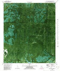
1981 Map of Tates Hell Swamp
USGS Topo · Published 1982About this map
Tates Hell Swamp dominates this orthophotomap of the Florida Panhandle, revealing the intricate water and forest patterns of Franklin County in the early 1980s. Unlike traditional topographic maps, this aerial-derived sheet provides a photographic record of the dense canopy and wetlands, cut through by human infrastructure like the Old Railroad Grade and Buck Siding Road. The settlement at Five Points and the winding course of Whiskey George Creek highlight the isolated pockets of activity within this vast interior. Boundary lines for the historical Forbes Purchase are clearly delineated, marking a significant piece of Florida land history. The drainage network, including Gully Branch, illustrates the low-lying hydrology typical of this Gulf Coast region before modern conservation efforts shifted the landscape's management.
Find a feature on this map
8 named features on this map. Tap any name to fly to it.
Don’t see what you’re looking for? This feature index may not catch every label — zoom into the map to look around manually.
Map Details
Editions of this 1981 Tates Hell Swamp Map
This is the sole edition of this map. No revisions or reprints were ever made.
Other maps of this area

1943 · Carrabelle
USGS Topo · 1:24,000

1944 · Pickett Bay
USGS Topo · 1:31,680

1944 · Carrabelle
USGS Topo · 1:31,680

1944 · Green Point
USGS Topo · 1:31,680

1945 · Thousand Yard Bay
USGS Topo · 1:31,680

1945 · Tates Hell Swamp
USGS Topo · 1:31,680

1945 · Beverly
USGS Topo · 1:31,680

1945 · Pickett Bay
USGS Topo · 1:31,680

1945 · Fort Gadsden
USGS Topo · 1:31,680

1946 · Sumatra
USGS Topo · 1:31,680