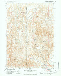
1951 Map of Tatman Mountain
USGS Topo · Published 1978About this map
The boundary between Park County and Big Horn County cuts through this high-elevation landscape in the early 1950s, a period when the Department of the Interior focused on the development of the Missouri River Basin. The topography is dominated by the broad, elevated plateau of Tatman Mountain, rising above a network of erosion-carved drainages. Narrow passages like Fenton Pass provide the only natural travel corridors through the steep breaks, while Fenton Draw and Roach Gulch mark the seasonal watercourses that define the local drainage pattern. Further south, Sheets Mountain and the deep incision of Blackburn Gulch illustrate the isolation of this Wyoming backcountry. This survey, based on aerial photography from Fairchild Aerial Surveys, captures the area before significant modern modification, preserving the locations of critical water sources like the isolated Spring located east of the mountain peak.
Find a feature on this map
8 named features on this map. Tap any name to fly to it.
Don’t see what you’re looking for? This feature index may not catch every label — zoom into the map to look around manually.
Map Details
Editions of this 1951 Tatman Mountain Map
2 editions found
Other maps of this area

1951 · Burlington
USGS Topo · 1:24,000

1951 · Y U Bench NW
USGS Topo · 1:24,000

1951 · Y U Bench NE
USGS Topo · 1:24,000

1951 · Sheep Mountain
USGS Topo · 1:24,000

1951 · Tatman Mountain
USGS Topo · 1:24,000

1951 · Sheets Flat
USGS Topo · 1:24,000

1951 · Wilson Spring
USGS Topo · 1:24,000

1951 · Dead Indian Hill
USGS Topo · 1:24,000

1951 · Dutch Nick Flat NW
USGS Topo · 1:24,000

1955 · Cody
USGS Topo · 1:250,000