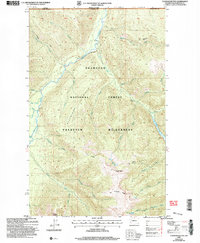
2002 Map of Tatoosh Buttes
USGS Topo · Published 2006About this map
The Pasayten River flows north toward the Canadian border through this remote section of the Okanogan National Forest. This landscape is defined by the high elevations of Ptarmigan Ridge and the Tatoosh Buttes, where seasonal outposts like Lone Buck Camp and Gunbarrel Camp suggest a long history of wilderness pack travel and forest management. High-altitude water bodies, including Ptarmigan Lake and the White Lakes, feed a network of drainages such as Gunbarrel Creek and Harrison Creek. The topographic survey highlights the complex drainage system of the East Fork Pasayten River as it carves through the protected Pasayten Wilderness, providing a clear view of the area's natural boundaries and trails before later modernization.
Find a feature on this map
45 named features on this map. Tap any name to fly to it.
Don’t see what you’re looking for? This feature index may not catch every label — zoom into the map to look around manually.
Map Details
Editions of this 2002 Tatoosh Buttes Map
This is the sole edition of this map. No revisions or reprints were ever made.
Other maps of this area

1920 · Slate Pass
USGS Topo · 1:125,000

1955 · Concrete
USGS Topo · 1:250,000

1958 · Concrete
USGS Topo · 1:250,000

1962 · Concrete
USGS Topo · 1:250,000

1969 · Frosty Creek
USGS Topo · 1:24,000

1969 · Lost Peak
USGS Topo · 1:24,000
1969 · Pasayten Peak
USGS Topo · 1:24,000
1969 · Ashnola Mtn
USGS Topo · 1:24,000

1969 · Tatoosh Buttes
USGS Topo · 1:24,000
1969 · Mount Lago
USGS Topo · 1:24,000