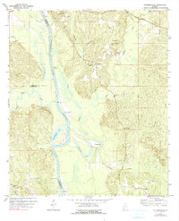
1972 Map of Tattlersville
USGS Topo · Published 1991About this map
The Tombigbee River serves as a defining boundary in this area of southwest Alabama, separating Clarke, Choctaw, and Washington counties. Along the river’s winding course, river traffic and local trade are evidenced by several historic access points, including Christmas Landing, Baileys Landing, and Blount Landing. The floodplain is characterized by complex hydrology, featuring abandoned river loops and backwaters like Horseshoe Lake, Round Pond, and Hatchetigbee Lake at the foot of the Hatchetigbee Hills.
Find a feature on this map
41 named features on this map. Tap any name to fly to it.
Don’t see what you’re looking for? This feature index may not catch every label — zoom into the map to look around manually.
Map Details
Editions of this 1972 Tattlersville Map
2 editions found
Other maps of this area

1953 · Andalusia
USGS Topo · 1:250,000

1953 · Hattiesburg
USGS Topo · 1:250,000

1957 · Andalusia
USGS Topo · 1:250,000

1958 · Hattiesburg
USGS Topo · 1:250,000

1971 · Bigbee
USGS Topo · 1:24,000

1971 · Coffeeville
USGS Topo · 1:24,000

1971 · Bladon Springs
USGS Topo · 1:24,000

1971 · Coffeeville Lock And Dam
USGS Topo · 1:24,000

1972 · Tattlersville
USGS Topo · 1:24,000

1972 · St. Stephens
USGS Topo · 1:24,000