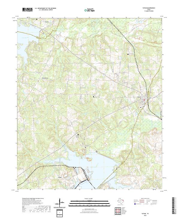
2022 Map of Tatum
USGS Topo · Published 2022About this map
The boundary between Rusk, Panola, and Gregg Counties defines this corner of East Texas, where the community of Tatum sits as a central hub for local industry and residence. To the south, the expansive waters of Martin Lake dominate the terrain, while the northern reaches are shaped by the winding course of Cherokee Bayou and the eastern arm of Lake Cherokee. This survey illustrates a landscape deeply connected to its local heritage, evidenced by numerous family and community burial grounds such as Harmony Hill Cem, Vinson Cem, and Zion Hill Cem.
Find a feature on this map
94 named features on this map. Tap any name to fly to it.
Don’t see what you’re looking for? This feature index may not catch every label — zoom into the map to look around manually.
Map Details
Editions of this 2022 Tatum Map
This is the sole edition of this map. No revisions or reprints were ever made.
Other maps of this area

1956 · Tyler
USGS Topo · 1:250,000

1958 · Darco
USGS Topo · 1:62,500

1958 · Carthage
USGS Topo · 1:62,500

1958 · Tatum
USGS Topo · 1:62,500

1960 · Minden
USGS Topo · 1:62,500

1983 · Tatum
USGS Topo · 1:24,000

1983 · Harris Chapel
USGS Topo · 1:24,000

1983 · Easton
USGS Topo · 1:24,000
1983 · Lakeport
USGS Topo · 1:24,000
1983 · Church Hill
USGS Topo · 1:24,000