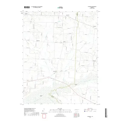
2019 Map of Tatumville
USGS Topo · Published 2019About this map
Tatumville and its surrounding rural communities occupy this landscape along the border of Dyer and Gibson counties. The area is defined by a dense network of country roads named for local families, including Adkins Cemetery Rd, Haywood Thompson Rd, and Bobby Thompson Rd, which connect small settlements like Edgewood, Lapata, and Neboville. The southern portion of the map transitions into the low-lying wetlands of the Tatumville Bottom and Macedonia Bottom.
Find a feature on this map
83 named features on this map. Tap any name to fly to it.
Don’t see what you’re looking for? This feature index may not catch every label — zoom into the map to look around manually.
Map Details
Editions of this 2019 Tatumville Map
This is the sole edition of this map. No revisions or reprints were ever made.
Other maps of this area

1939 · Dyersburg
USGS Topo · 1:62,500

1939 · Halls
USGS Topo · 1:62,500

1952 · Bonicord
USGS Topo · 1:24,000

1952 · Newbern
USGS Topo · 1:24,000

1952 · Lane
USGS Topo · 1:24,000

1956 · Dyersburg
USGS Topo · 1:250,000

1956 · Blytheville
USGS Topo · 1:250,000

1959 · Blytheville
USGS Topo · 1:250,000

1961 · Halls
USGS Topo · 1:62,500
1961 · Dyersburg
USGS Topo · 1:62,500