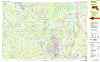
1987 Map of Taunton
USGS Topo · Published 1987About this map
The industrial and educational hub of Taunton anchor this 1980s landscape, where the Taunton River winds past established neighborhoods like Whittenton and Weir Village. The map records a complex network of infrastructure, from the Conrail and Amtrak rail lines to the institutional presence of Wheaton College in Norton and the sprawling Dever State School.
Find a feature on this map
102 named features on this map. Tap any name to fly to it.
Don’t see what you’re looking for? This feature index may not catch every label — zoom into the map to look around manually.
Map Details
Editions of this 1987 Taunton Map
2 editions found
Other maps of this area

1885 · Abington
USGS Topo · 1:62,500

1885 · Middleboro
USGS Topo · 1:62,500

1885 · Taunton
USGS Topo · 1:62,500

1886 · Dedham
USGS Topo · 1:62,500

1887 · Franklin
USGS Topo · 1:62,500

1887 · Providence
USGS Topo · 1:62,500

1888 · Taunton
USGS Topo · 1:62,500

1888 · Middleboro
USGS Topo · 1:62,500

1888 · Abington
USGS Topo · 1:62,500

1889 · Providence
USGS Topo · 1:62,500