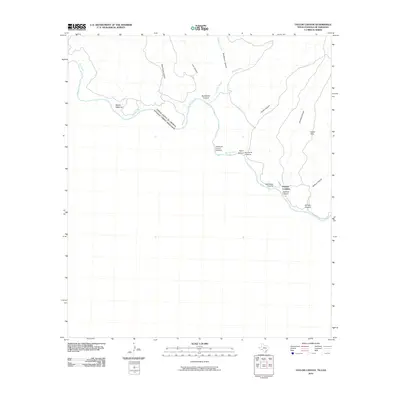
2010 Map of Taylor Canyon
USGS Topo · Published 2010About this map
Dryden Crossing sits at the southern edge of this West Texas landscape, where the international boundary between the United States and Mexico is defined by the winding course of the Rio Grande. The terrain is deeply incised by a series of significant drainage systems, most notably Taylor Canyon, Sanderson Canyon, and Jabalina Canyon, which flow toward the river through the high country. These canyons create a network of natural corridors that lead to critical river access points such as Agua Verde Crossing and Paso Verde Crossing. Along the northern bends of the river, isolated landmarks like Middle Watering and the Cable Hills provide further navigational context in a region where the dry creek beds of Garcia Creek and Sanderson Creek dictate the movement of both water and traveler alike.
Find a feature on this map
17 named features on this map. Tap any name to fly to it.
Don’t see what you’re looking for? This feature index may not catch every label — zoom into the map to look around manually.
Map Details
Editions of this 2010 Taylor Canyon Map
This is the sole edition of this map. No revisions or reprints were ever made.
Other maps of this area

1918 · Dryden Crossing
USGS Topo · 1:62,500

1918 · Indian Wells
USGS Topo · 1:62,500

1959 · Emory Peak
USGS Topo · 1:250,000

1965 · Emory Peak
USGS Topo · 1:250,000
1983 · Panther Gulch East
USGS Topo · 1:24,000
1983 · Balcon Creek
USGS Topo · 1:24,000
1983 · Taylor Canyon
USGS Topo · 1:24,000
1983 · Candilla Canyon East
USGS Topo · 1:24,000
1983 · McClain Canyon
USGS Topo · 1:24,000
1983 · Shafter Canyon
USGS Topo · 1:24,000