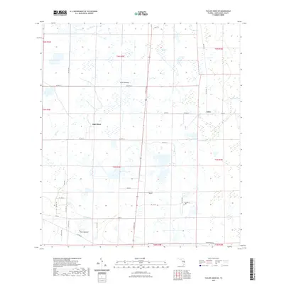
2021 Map of Taylor Creek NE
USGS Topo · Published 2021About this map
Eagle Island and White Hammock anchor this interior Florida landscape, where the flatlands of Okeechobee County are defined by a complex network of seasonal sloughs and creek drainages. The mapping reveals a distinct settlement pattern where clusters of buildings are often situated on slightly elevated hammocks, or islands, surrounded by the wetlands of Joe Gore Slough and Parker Bay. Waterways like Taylor Creek and Fort Drum Creek provide the primary natural drainage, while a grid of rural roads such as Rucks Road and County Road 68 facilitates movement through the cattle country. The presence of Gary Stark Airport toward the southern end of the quadrangle indicates modern infrastructure integrated into this traditionally agricultural and ranching environment. Small rural locales like Hilolo further illustrate the sparse but deliberate distribution of homesteads across this expansive prairie and marshland region.
Find a feature on this map
31 named features on this map. Tap any name to fly to it.
Don’t see what you’re looking for? This feature index may not catch every label — zoom into the map to look around manually.
Map Details
Editions of this 2021 Taylor Creek NE Map
This is the sole edition of this map. No revisions or reprints were ever made.
Other maps of this area

1953 · Taylor Creek NW
USGS Topo · 1:24,000

1953 · Fort Drum
USGS Topo · 1:24,000

1953 · Fort Drum SW
USGS Topo · 1:24,000

1953 · Fellsmere 4 SW
USGS Topo · 1:24,000

1953 · Taylor Creek SW
USGS Topo · 1:24,000

1953 · Okeechobee 1 SW
USGS Topo · 1:24,000

1953 · Taylor Creek SE
USGS Topo · 1:24,000

1953 · Taylor Creek NE
USGS Topo · 1:24,000

1953 · Okeechobee 1 NW
USGS Topo · 1:24,000

1956 · Fort Pierce
USGS Topo · 1:250,000