1967 Map of Taylor Monument
USGS Topo · Published 1977About this map
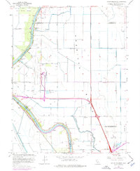
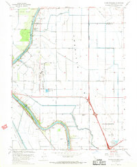
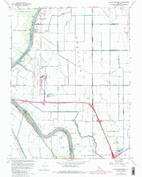
The Sacramento River and American River converge in this mid-century survey, defining a landscape shaped by water management and transit infrastructure. The vast Yolo Bypass dominates the western edge, designated as an inundation area to protect the surrounding agricultural and residential zones. Central to the sheet is the Sacramento Metropolitan Airport, its runways and facilities carved out from the flatlands near Meister Way.
Find a feature on this map
43 named features on this map. Tap any name to fly to it.
Don’t see what you’re looking for? This feature index may not catch every label — zoom into the map to look around manually.
Map Details
Editions of this 1967 Taylor Monument Map
4 editions found
Historical Maps of Sacramento Through Time
71 maps found

1902 Fairoaks
Sacramento County, CA

1908 Buffalo Creek
Sacramento County, CA

1909 Carbondale
Sacramento County, CA

1909 Cosumnes
Sacramento County, CA

1909 Goose Creek
Sacramento County, CA

1910 Bruceville
Sacramento County, CA

1910 Jersey
Sacramento County, CA

1911 Arcade
Sacramento County, CA

1911 Brighton
Sacramento County, CA

1911 Mills
Sacramento County, CA

1915 Elkhorn Weir
Sacramento County, CA

1916 Buffalo Creek
Sacramento County, CA

1916 Vorden
Sacramento County, CA

1941 Franklin
Sacramento County, CA

1949 Sacramento East
Sacramento County, CA

1950 Taylor Monument
Sacramento County, CA

1951 Taylor Monument
Sacramento County, CA

1952 Jersey Island
Sacramento County, CA

1953 Bruceville
Sacramento County, CA

1953 Carbondale
Sacramento County, CA

1953 Goose Creek
Sacramento County, CA

1953 Sloughhouse
Sacramento County, CA

1954 Buffalo Creek
Sacramento County, CA

1954 Folsom SE
Sacramento County, CA

1954 Sacramento East
Sacramento County, CA

1967 Buffalo Creek
Sacramento County, CA

1967 Sacramento East
Sacramento County, CA

1967 Taylor Monument
Sacramento County, CA

1968 Bruceville
Sacramento County, CA

1968 Carbondale
Sacramento County, CA

1968 Goose Creek
Sacramento County, CA

1968 Sloughhouse
Sacramento County, CA

1978 Jersey Island
Sacramento County, CA

1992 Sacramento East
Sacramento County, CA

1997 Goose Creek
Sacramento County, CA

2012 Bruceville
Sacramento County, CA

2012 Buffalo Creek
Sacramento County, CA

2012 Carbondale
Sacramento County, CA

2012 Folsom SE
Sacramento County, CA

2012 Goose Creek
Sacramento County, CA

2012 Jersey Island
Sacramento County, CA

2012 Sacramento East
Sacramento County, CA

2012 Sloughhouse
Sacramento County, CA

2012 Taylor Monument
Sacramento County, CA

2015 Bruceville
Sacramento County, CA

2015 Buffalo Creek
Sacramento County, CA

2015 Carbondale
Sacramento County, CA

2015 Folsom SE
Sacramento County, CA

2015 Goose Creek
Sacramento County, CA

2015 Jersey Island
Sacramento County, CA

2015 Sacramento East
Sacramento County, CA

2015 Sloughhouse
Sacramento County, CA

2015 Taylor Monument
Sacramento County, CA

2018 Bruceville
Sacramento County, CA

2018 Buffalo Creek
Sacramento County, CA

2018 Carbondale
Sacramento County, CA

2018 Folsom SE
Sacramento County, CA

2018 Goose Creek
Sacramento County, CA

2018 Jersey Island
Sacramento County, CA

2018 Sacramento East
Sacramento County, CA

2018 Sloughhouse
Sacramento County, CA

2018 Taylor Monument
Sacramento County, CA

2021 Bruceville
Sacramento County, CA

2021 Buffalo Creek
Sacramento County, CA

2021 Jersey Island
Sacramento County, CA

2021 Sacramento East
Sacramento County, CA

2021 Taylor Monument
Sacramento County, CA

2022 Carbondale
Sacramento County, CA

2022 Folsom SE
Sacramento County, CA

2022 Goose Creek
Sacramento County, CA

2022 Sloughhouse
Sacramento County, CA