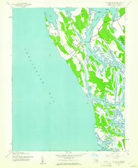
1942 Map of Taylors Island
USGS Topo · Published 1961About this map
Taylors Island and the surrounding marshy necks of Dorchester County define this 1942 survey of the Eastern Shore. The landscape is a complex network of tidal guts and coves where the Chesapeake Bay meets the mainland. Small settlements like Smithville and the village at Taylors Island serve as centers for a community deeply tied to the water, connected by State Routes 16 and 335. Local landmarks such as Bethlehem Ch and Grace Ch provide critical anchor points for genealogists and family historians tracing the early 20th-century social geography of this region. The map details the intricate shoreline of Slaughter Creek and Robinson Neck, illustrating a world of landings and island passages including Dunnock Island and the open waters of The Big Broads. This survey was conducted just as aerial photogrammetry began to precisely document the shifting marshes and coastal boundaries of Maryland's tidewater country.
Find a feature on this map
46 named features on this map. Tap any name to fly to it.
Don’t see what you’re looking for? This feature index may not catch every label — zoom into the map to look around manually.
Map Details
Editions of this 1942 Taylors Island Map
This is the sole edition of this map. No revisions or reprints were ever made.
Other maps of this area

1892 · Drum Point
USGS Topo · 1:62,500

1893 · Sharps Island
USGS Topo · 1:62,500

1898 · Choptank
USGS Topo · 1:125,000

1898 · St. Marys
USGS Topo · 1:125,000

1901 · Drum Point
USGS Topo · 1:62,500

1904 · Sharps Island
USGS Topo · 1:62,500

1904 · Oxford
USGS Topo · 1:62,500

1905 · Crapo
USGS Topo · 1:62,500

1905 · Drum Point
USGS Topo · 1:62,500

1906 · St. Marys
USGS Topo · 1:125,000