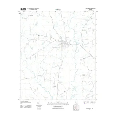
2012 Map of Taylorsville
USGS Topo · Published 2012About this map
Taylorsville serves as the central hub of this Smith County landscape, which is defined by a mix of rural settlements and active industrial resource extraction. The area around Wisner and the Summerland Oil and Gas Field indicates the continuing importance of energy production to the local economy. In contrast to the modern infrastructure of the Smith County Airport, markers of earlier history are found at Old Taylorsville and several family or community burial grounds, including Clear Creek Cem and New Hopewell Cem. The terrain is drained by a network of waterways such as the Leaf River and Oakhay Creek, which have influenced the placement of small communities like Gambrell and Gilmore. This 2012 survey provides a clear view of the road network and land use patterns that define this section of Mississippi.
Find a feature on this map
98 named features on this map. Tap any name to fly to it.
Don’t see what you’re looking for? This feature index may not catch every label — zoom into the map to look around manually.
Map Details
Editions of this 2012 Taylorsville Map
This is the sole edition of this map. No revisions or reprints were ever made.
Other maps of this area

1953 · Hattiesburg
USGS Topo · 1:250,000

1958 · Hattiesburg
USGS Topo · 1:250,000

1965 · Hebron
USGS Topo · 1:24,000

1965 · Hot Coffee
USGS Topo · 1:24,000

1974 · Soso
USGS Topo · 1:24,000

1974 · Collins
USGS Topo · 1:24,000
1974 · Bay Springs
USGS Topo · 1:24,000
1975 · Cohay
USGS Topo · 1:24,000

1975 · Taylorsville
USGS Topo · 1:24,000

1975 · Mize
USGS Topo · 1:24,000