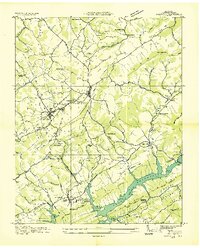
1936 Map of Tazewell
USGS Topo · Published 1936About this map
Tazewell and New Tazewell serve as the primary hubs of Claiborne County in this mid-1930s survey, conducted during a period of massive landscape transformation. The southern portion of the map is dominated by the emerging Norris Reservoir, a Tennessee Valley Authority project that altered local geography and property lines. The Southern railroad line cuts through the center of the sheet, passing through the Greer Tunnel and connecting the rural community of Springdale to the larger towns.
Find a feature on this map
54 named features on this map. Tap any name to fly to it.
Don’t see what you’re looking for? This feature index may not catch every label — zoom into the map to look around manually.
Map Details
Editions of this 1936 Tazewell Map
This is the sole edition of this map. No revisions or reprints were ever made.
Other maps of this area

1883 · Morristown
USGS Topo · 1:125,000

1886 · Cumberland Gap
USGS Topo · 1:125,000

1887 · Jonesville
USGS Topo · 1:125,000

1888 · Cumberland Gap
USGS Topo · 1:125,000

1891 · Cumberland Gap
USGS Topo · 1:125,000

1891 · Jonesville
USGS Topo · 1:125,000

1893 · Morristown
USGS Topo · 1:125,000

1895 · Morristown
USGS Topo · 1:125,000

1897 · Maynardville
USGS Topo · 1:125,000

1900 · Maynardville
USGS Topo · 1:125,000