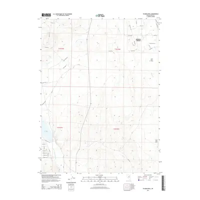
2014 Map of Te-Moak Well
USGS Topo · Published 2014About this map
Te-Moak Well and the residential expansion of Spring Creek characterize this high-desert landscape in Elko County. The map details a transition from the structured street grids of newer suburban developments—featuring named ways like Pioneer Way and Pony Express Way—to the open reaches of the South Fork Valley. This 2014 survey documents the hydrography of the region, anchored by the South Fork Humboldt River and its feeder streams including Tenmile Cr and Mitchell Cr. The western edge of the quadrangle shows the shoreline of the S Fork Reservoir, while historical transportation routes are recalled by the presence of the Emigrant Trl and Hilltop Dr. The layout reveals a distinct pattern of modern land use superimposed over traditional western terrain, where high-density street names like Avocet St and Marshall Ave give way to the expansive Public Land Survey System sections.
Find a feature on this map
44 named features on this map. Tap any name to fly to it.
Don’t see what you’re looking for? This feature index may not catch every label — zoom into the map to look around manually.
Map Details
Editions of this 2014 Te-Moak Well Map
This is the sole edition of this map. No revisions or reprints were ever made.
Other maps of this area
1952 · Dixie Flats
USGS Topo · 1:62,500

1955 · Elko
USGS Topo · 1:250,000
1957 · Elko West
USGS Topo · 1:24,000
1957 · Elko East
USGS Topo · 1:24,000

1958 · Elko
USGS Topo · 1:250,000

1962 · Elko
USGS Topo · 1:250,000
1962 · Boyd Reservoir
USGS Topo · 1:24,000
1962 · Elko East
USGS Topo · 1:24,000
1962 · Elko West
USGS Topo · 1:24,000
1962 · Lee
USGS Topo · 1:62,500