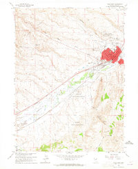
1962 Map of Elko West
USGS Topo · Published 1965About this map
Elko serves as the focal point of this Nevada survey, showing the city's development alongside the Southern Pacific and Western Pacific railroads. The town's mid-century infrastructure is well-defined, featuring the Elko Municipal Airport, the County Fairgrounds, and a Drive-in Theater. To the north and south, the Elko Colony Indian Reservation and Te-Moak Indian Reservation occupy significant portions of the landscape.
Find a feature on this map
35 named features on this map. Tap any name to fly to it.
Don’t see what you’re looking for? This feature index may not catch every label — zoom into the map to look around manually.
Map Details
Editions of this 1962 Elko West Map
Other maps of this area

1952 · Dixie Flats
USGS Topo · 1:62,500

1955 · Elko
USGS Topo · 1:250,000

1957 · Elko West
USGS Topo · 1:24,000

1957 · Elko East
USGS Topo · 1:24,000

1958 · Elko
USGS Topo · 1:250,000

1958 · Hunter
USGS Topo · 1:24,000

1958 · Doby Summit
USGS Topo · 1:24,000

1962 · Elko
USGS Topo · 1:250,000

1962 · Kittridge Springs
USGS Topo · 1:24,000

1962 · Osino
USGS Topo · 1:24,000