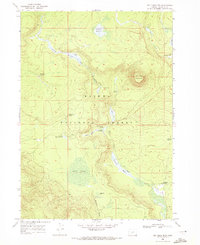
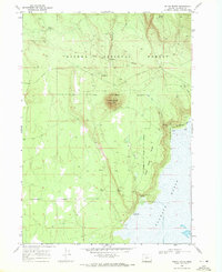
1968 Map of Tea Table Mtn
USGS Topo · Published 1972About this map
Tea Table Mountain rises as a central landmark within this portion of the Winema National Forest as it appeared in the late 1960s. The landscape is defined by a dense network of water sources and meadows, indicating a high-elevation environment where seasonal water management was critical. To the north, Jamison Ranch and Jamison Meadow suggest a history of localized grazing or homesteading, supported by Jack Creek and Rock Creek. These features, along with names like The Rhubarb Patch and Jackies Thicket, reflect a vernacular geography tied to early settlers and forest users. Remote outposts such as Riders Camp and Lily Camp are connected by forest roads, providing access to spring sites including Huckleberry Spring, Cleary Spring, and the curiously named Yellow Jacket Spring. The presence of Jack O'Conner Meadow and Stimson Meadow further illustrates how this timber and range land was partitioned and utilized during the mid-20th century.
Find a feature on this map
24 named features on this map. Tap any name to fly to it.
Don’t see what you’re looking for? This feature index may not catch every label — zoom into the map to look around manually.
Map Details
Editions of this 1968 Tea Table Mtn Map
This is the sole edition of this map. No revisions or reprints were ever made.
Other maps of this area

1935 · Chemult
USGS Topo · 1:96,000

1941 · Chemult
USGS Topo · 1:125,000

1955 · Crescent
USGS Topo · 1:250,000

1957 · Crescent
USGS Topo · 1:250,000

1958 · Crescent
USGS Topo · 1:250,000
1967 · Walker Mtn
USGS Topo · 1:24,000
1967 · Sellers Marsh
USGS Topo · 1:24,000

1968 · Location Butte
USGS Topo · 1:24,000
1968 · Sugarpine Mtn.
USGS Topo · 1:24,000
1968 · Round Butte
USGS Topo · 1:24,000