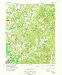
1971 Map of Teague
USGS Topo · Published 1971About this map
The Hatchie River Bottom dominates the southwestern corner of this West Tennessee landscape, where the Hatchie River winds through a complex network of wetlands like Otter Pond and Horseshoe Pond. Compiled by the U.S. Army Corps of Engineers, the map illustrates the rural intersection of Madison, Hardeman, and Chester Counties during a period of transition for small rail-dependent towns. The Gulf Mobile & Ohio RR and Illinois Central RR lines serve as the primary transport corridors, connecting settlements such as Medon, Toone, and Silerton. Significant acreage is dedicated to the Chickasaw State Park, which encompasses several water bodies including Lake Placid and Ben Henry Lake. For local historians, the map is remarkably dense with family-named landmarks and community centers, from the Toone Sch to numerous rural congregations like Maple Springs Ch and New Union Ch. Numerous small burial grounds, such as Yarbrough Cem and Hickory Grove Cem, are distributed across the hills, offering a detailed record of the mid-20th-century settlement pattern.
Find a feature on this map
108 named features on this map. Tap any name to fly to it.
Don’t see what you’re looking for? This feature index may not catch every label — zoom into the map to look around manually.
Map Details
Editions of this 1971 Teague Map
This is the sole edition of this map. No revisions or reprints were ever made.
Other maps of this area

1950 · Jackson South
USGS Topo · 1:24,000

1950 · Hebron
USGS Topo · 1:24,000

1950 · Hornsby
USGS Topo · 1:24,000

1950 · Middleburg
USGS Topo · 1:24,000

1951 · Middleburg
USGS Topo · 1:24,000

1951 · Hebron
USGS Topo · 1:24,000

1951 · Hornsby
USGS Topo · 1:24,000

1951 · Rose Creek
USGS Topo · 1:24,000

1953 · Beech Bluff
USGS Topo · 1:24,000

1956 · Blytheville
USGS Topo · 1:250,000