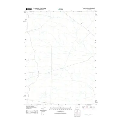
2012 Map of Teakettle Butte
USGS Topo · Published 2012About this map
The historic passage of the California-Oregon Trl cuts across the southern portion of this high desert landscape in Sweetwater County. This 2012 Bureau of Land Management and USGS survey details a rugged section of Wyoming where modern infrastructure overlays ancestral paths. The namesake Teakettle Butte rises as a prominent landmark in the northeast, serving as a natural navigational beacon in an area otherwise defined by ephemeral drainage patterns and vast open space.
Find a feature on this map
7 named features on this map. Tap any name to fly to it.
Don’t see what you’re looking for? This feature index may not catch every label — zoom into the map to look around manually.
Map Details
Editions of this 2012 Teakettle Butte Map
This is the sole edition of this map. No revisions or reprints were ever made.
Other maps of this area

1955 · Lander
USGS Topo · 1:250,000

1958 · Lander
USGS Topo · 1:250,000

1961 · Lander
USGS Topo · 1:250,000
1968 · Twelvemile Knoll
USGS Topo · 1:24,000
1968 · Monument Butte NE
USGS Topo · 1:24,000
1968 · Fourmile Knoll
USGS Topo · 1:24,000
1969 · Sugar Loaf
USGS Topo · 1:24,000
1969 · Juel Spring
USGS Topo · 1:24,000
1969 · Teakettle Butte
USGS Topo · 1:24,000
1969 · Bull Draw
USGS Topo · 1:24,000