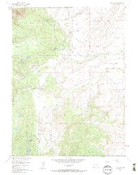
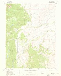
1955 Map of Teal Lake
USGS Topo · Published 1961About this map
Manville Ranch and Geer Ranch anchor this mid-century look at the high country near the western edge of the Missouri River Basin. The landscape is defined by an intricate network of water management, visible through the numerous labeled waterways like Grizzly Creek and Beaver Creek, alongside human-engineered features such as the Glendale Ditch and Andrew Morell Ditch. This reliance on ditching and reservoirs like Burns Reservoir and Ross Reservoir illustrates the critical role of irrigation in sustaining mountain ranching operations during the 1950s.
Find a feature on this map
75 named features on this map. Tap any name to fly to it.
Don’t see what you’re looking for? This feature index may not catch every label — zoom into the map to look around manually.
Map Details
Editions of this 1955 Teal Lake Map
6 editions found
Other maps of this area

1911 · Hahns Peak
USGS Topo · 1:125,000

1913 · Hahns Peak
USGS Topo · 1:125,000

1954 · Craig
USGS Topo · 1:250,000

1955 · Buffalo Pass
USGS Topo · 1:24,000

1955 · Pitchpine Mountain
USGS Topo · 1:24,000

1955 · Mount Ethel
USGS Topo · 1:24,000

1955 · Teal Lake
USGS Topo · 1:24,000

1955 · Delaney Butte
USGS Topo · 1:24,000

1955 · Coalmont
USGS Topo · 1:24,000

1955 · Mount Ethel
USGS Topo · 1:62,500