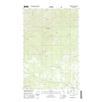
2017 Map of Teanaway Butte
USGS Topo · Published 2017About this map
The confluence of the Middle Fork Teanaway River and North Fork Teanaway River creates a high-elevation landscape dominated by the protected timberlands of the Wenatchee National Forest. This 2017 study illustrates the complex drainage network of the Cascades, where Way Creek and Jungle Creek feed into the river system. Local landmarks such as Liars Prairie and Teanaway Butte stand out among the peaks of Koppen Mtn and Malcolm Mtn. While largely a wilderness area, the map details a network of forestry and access roads like Teanaway Road Middle Frk and W Fork Teanaway Rd, alongside the localized naming of Camp Seventeen Canyon and Carlson Canyon that hint at the region's history with logging camps and early transport routes.
Find a feature on this map
40 named features on this map. Tap any name to fly to it.
Don’t see what you’re looking for? This feature index may not catch every label — zoom into the map to look around manually.
Map Details
Editions of this 2017 Teanaway Butte Map
This is the sole edition of this map. No revisions or reprints were ever made.
Other maps of this area
1897 · Mount Stuart
USGS Topo · 1:125,000
1901 · Snoqualmie Pass
USGS Topo · 1:125,000
1902 · Mount Stuart
USGS Topo · 1:125,000
1903 · Snoqualmie
USGS Topo · 1:125,000
1957 · Wenatchee
USGS Topo · 1:250,000
1958 · Cle Elum
USGS Topo · 1:62,500
1961 · Mount Stuart
USGS Topo · 1:62,500
1961 · Easton
USGS Topo · 1:62,500
1961 · Kachess Lake
USGS Topo · 1:62,500
1975 · Snoqualmie Pass
USGS Topo · 1:100,000