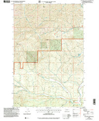
2003 Map of Teanaway Butte
USGS Topo · Published 2006About this map
Wenatchee National Forest dominates this mountain landscape, centered on the prominent elevation of Teanaway Butte. The map details a complex drainage system where the Middle Fork Teanaway River and North Fork Teanaway River converge, fed by numerous seasonal and perennial streams like Jungle Creek and Malcolm Creek. The terrain is defined by significant ridges and peaks including Malcolm Mountain, Yellow Hill, and the southern Cle Elum Ridge.
Find a feature on this map
27 named features on this map. Tap any name to fly to it.
Don’t see what you’re looking for? This feature index may not catch every label — zoom into the map to look around manually.
Map Details
Editions of this 2003 Teanaway Butte Map
This is the sole edition of this map. No revisions or reprints were ever made.
Other maps of this area

1897 · Mount Stuart
USGS Topo · 1:125,000

1901 · Snoqualmie Pass
USGS Topo · 1:125,000

1902 · Mount Stuart
USGS Topo · 1:125,000

1903 · Snoqualmie
USGS Topo · 1:125,000

1957 · Wenatchee
USGS Topo · 1:250,000

1958 · Cle Elum
USGS Topo · 1:62,500

1961 · Mount Stuart
USGS Topo · 1:62,500

1961 · Easton
USGS Topo · 1:62,500

1961 · Kachess Lake
USGS Topo · 1:62,500

1975 · Snoqualmie Pass
USGS Topo · 1:100,000