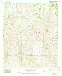
1964 Map of Teapot Mountain
USGS Topo · Published 1973About this map
Tonto National Forest lands dominate the northern landscape of this Pinal County region, where the high desert is carved by deep drainage systems like Devils Canyon and Arnett Creek. The southern portion reveals an intensive copper mining landscape during the early 1960s, centered around the Copper Butte Mine and the industrial activity near Ray. The presence of large-scale infrastructure, including several Leaching Ponds and the West Pit, indicates the significant geological impact of the Mineral Creek district's extraction operations.
Find a feature on this map
37 named features on this map. Tap any name to fly to it.
Don’t see what you’re looking for? This feature index may not catch every label — zoom into the map to look around manually.
Map Details
Editions of this 1964 Teapot Mountain Map
3 editions found
Other maps of this area

1900 · Florence
USGS Topo · 1:125,000

1901 · Globe
USGS Topo · 1:62,500

1902 · Globe
USGS Topo · 1:62,500

1902 · Florence
USGS Topo · 1:125,000

1910 · Ray
USGS Topo · 1:62,500

1948 · Pinal Ranch
USGS Topo · 1:24,000

1948 · Superior
USGS Topo · 1:62,500

1948 · Superior
USGS Topo · 1:24,000

1948 · Picketpost Mtn
USGS Topo · 1:24,000

1949 · Pinal Ranch
USGS Topo · 1:24,000